An update on the Dennistoun Community Council (DCC) enquiry sent on 15th March 2021 regarding the Spaces for People (SfP) ‘Low Traffic Neighbourhood’ scheme in Dennistoun, asking ten questions arising.
Glasgow City Council responded on 12th April 2021. That response was discussed at the DCC planning meeting held on 13th April 2021.
DCC then submitted comments and questions in return, to GCC, on 11th May 2021. It was copied to Dennistoun Ward Councillors Allan Casey, Kim Long and Elaine McDougall; Cllr Anna Richardson (City Convener for Sustainability and Carbon Reduction); and Sustrans Scotland.
Original DCC (March 2021) questions in black; GCC (April 2021) responses in blue; latest DCC (May 2021) comments and questions in green.
DCC Q1: Why have multiple through routes been left open in both directions between Duke Street and Alexandra Parade?
GCC: Following observation of the scheme at Dennistoun in practice, and in consideration of community feedback, we have taken the decision to remove some of the measures per the original scheme design, whilst retaining and maintaining those which most broadly meet the aim of creating extra space for physical distancing.
Modal filter planters which were previously installed to prevent motor vehicle access have now been removed from the undernoted streets, along with any associated signage and road markings:
- Ark Lane at Broompark Drive
- Armadale Street at Craigpark Drive (northbound)
- Craigpark at Craigpark Drive (northbound)
- Craigpark at Onslow Drive (southbound)
- Whitehill Street at Onslow Drive (southbound)
The recently introduced one-way systems and footway widening measures will be retained however at the locations below, ensuring more space for walking and wheeling around St Denis’ RC and Alexandra Parade Primary Schools and helping to ease congestion during the school run:
- Armadale Street (between Duke Street and Roslea Drive) – northbound
- Armadale Street (between Golfhill Drive and Alexandra Parade) – northbound
- Meadowpark Street (between Finlay Drive and Roslea Drive) – southbound
- Meadowpark Street at Ingleby Drive – northbound then westbound.
Full details of these short-term infrastructure changes have now been added to the Dennistoun Spaces for People webpage.
DCC: The response describes the process of downscaling the scheme. It does not explain why the original design opted not to remove through routes between Duke Street and Alexandra Parade.
The attached images show the many through routes that remained open with the full scheme in place (before various elements were removed). This is a significantly more permeable arrangement than what is generally understood to constitute a Low Traffic Neighbourhood, yet it is still being referred to as an LTN. This choice of description has led to a range of misunderstandings and frustrations being expressed and disseminated.
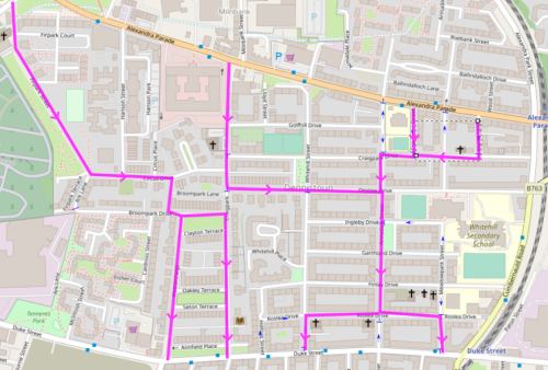

Why did the initial design and implementation leave multiple through routes open in both directions between Duke Street and Alexandra Parade?
DCC Q2: Temporary signage with poles in concrete blocks has been deemed sufficient in certain locations, so why have numerous new permanent signposts been installed elsewhere, for a scheme which is initially temporary and said to be easily changed in response to feedback?
GCC: The NAL temporary foundations have been used mainly at locations where road closure measures were in place meaning they are agile and can be readily adjusted to suit location variables should the need arise. New permanent sign poles have only been installed at locations where temporary infrastructure could not be used due to restrictions on the road / footway.
DCC: The quantity of permanent sign poles that were used, and the location they were used in, for a temporary scheme such as this, is not satisfactorily explained by simply citing undefined “restrictions on the road/footway”.
DCC Q3: The completion of the scheme and installation of missing no entry signage and markings. Why do the no entry points on Craigpark (at Craigpark Dr, and at Golfhill Dr), and on Armadale Street (at Craigpark Dr) have no entry signs on only one side of the road whilst other no entry points have signs on both sides of the road?
GCC: Signage installations were carried out dependent on site conditions and practicability.
DCC: It is not credible to simply cite “site conditions and practicability” for locations where no-entry signs on both sides of the road were not accommodated. This was a design decision made specifically for locations where the no-entry was half the carriageway width.
The result was very high levels of non-compliance: vehicles treated the planter arrangements at these locations as merely a chicane to be negotiated and exploited the ambiguity, with lawful driving immediately resumed at the other side of the planters. Drivers weren’t going through a no-entry point, they were merely going past one.
This is in contrast to no-entry points spanning the full carriageway width. E.g. the half-finished (one sign only) no-entry on Armadale Street at Roslea Drive, where the same high levels of non-compliance were in evidence despite the unavoidable 70 m length of one way road facing drivers opting to continue southward. But when the additional sign went up on the opposite side of the carriageway (along with supplementary road markings), compliance was massively improved.
The point being made here is that the designs for the half carriageway width no-entry points were of a deficient design. But rather than improve their implementation in an attempt to improve compliance, the option was taken to remove them altogether.
Why were the no-entry points on Criagpark and Armadale Street removed outright so soon after installation, with virtually no monitoring period during which the full scheme was in place, and without any attempt at improvement?
DCC Q4: What feedback has been received from emergency services?
GCC: Feedback was received from Police Scotland who raised concerns regarding the Contra-flow cycling proposals as well as concerns regarding the absence of further physical measures at some locations to discourage drivers from simply driving around the modal filter planters and ignoring ‘No Entry’ signage thus creating a significant enforcement burden.
DCC: As per Q3, DCC shared the concerns of the Police regarding the poorly designed no-entry points at modal filter planters. Why were improved no-entry points (with signs on both sides of the carriageway and no-entry road markings) not put in place?
It is exceedingly concerning, to say the least, that a legitimate traffic calming measure intended to create better safer streets right outside a primary school would be removed simply because of an anticipated additional “enforcement burden”.
Contraflow cycling is covered under Q5.
DCC Q5: Why has a Spaces for People active travel scheme ended up with less usable road space available to cycles – i.e. if a road was previously suitable for two-way mixed vehicular and cycle traffic, what specific additional risk was identified by having contraflow cycling permitted on a well-marked and signed vehicular one-way street (especially when it is within what is now being described as a low traffic neighbourhood and of identical geometry to vehicular two way roads which have no constraints on access to cycles)?
GCC: The contra-flow cycling element of the scheme was removed based on road widths and parked vehicles on both sides.
DCC: No specific additional risk has been identified. The issue of road widths and parked vehicles pre-exists on these roads with two-way traffic and it has not been explained how well-marked and signed one-way streets with contraflow cycling differ from this.
If a legitimate new risk arising from parked vehicles can in some way be identified, then it should be explained why an active travel scheme has been designed that preserves car parking spaces in preference to providing safe and direct cycle access.
In the current configuration, cycles are required to take longer and more circuitous routes than before the scheme was in place. This is unambiguously a downgrade to cycling provision.
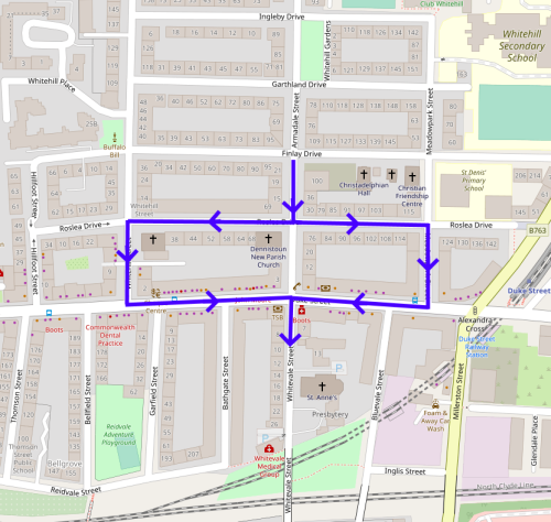
By way of illustration, consider the route from Armadale Street southbound toward Gallowgate and London Road via Whitevale Street (see attached image) – i.e. along quiet cycle-friendly streets, rather than busy carriageways with four vehicular lanes and no cycle provision. This journey now requires a diversion east or west along the vehicular route, and then back along Duke Street, navigating the additional junctions along the way. Has the additional risk created by the extended route to bypass south Armadale Street been balanced against the alleged risk of the previously proposed contraflow cycling?
It is precisely these sorts of diversions (rather than actually removing through routes altogether) which formed the basis of the claim that this is or was in any way a Low Traffic Neighbourhood scheme. If they were supposed to be a discouragement to vehicles then, at the very least, the same principle can be applied to cycles. And that doesn’t take into account the inevitable likelihood of some cyclists, in the face of a route option taken away, just choosing from the non-compliant options of either using the one-way as a contraflow anyway, or taking a route along the pavement. Should the evident increased enforcement burden at south Armadale Street be used as justification for removing the new configuration at this location?
Staying with that route – at the crossroads junction of Armadale Street and Roslea Drive, three of the four arms approaching it have give way markings. Per highway code rule 170 and associated laws, southbound vehicles on Armadale Street are on what is logically the “main road” and therefore have priority over these three give ways. But when two or more vehicles are approaching this crossroads from the south/west/east at the same time (a frequent occurrence) there is no clear priority for one vehicle over another: none of them are on the “main road”. Another frustration, and risk, for cyclists especially, when trying to navigate the new extended route. Is the road marking layout at the crossroads of Armadale Street and Roslea Drive confirmed as being fully compliant with legislation, or has approval for a deviation been given? Who has priority when two or more vehicles simultaneously approach this crossroads from the south/west/east?
Outside of Alexandra Parade primary school, the cycle symbol road markings have been removed. Does north Armadale Street outside Alexandra Parade primary school still have a contraflow cycle lane? If yes, why remove the road markings? If no, why have the temporary ‘no left/right turn except cycles’ signs been left in place?
DCC Q6: Why has a scheme initially given a two week installation programme ended up with three months being the revised installation period?
GCC: I can advise that as you are already aware the Council first began works to implement the proposed Dennistoun LTN on Tuesday 08 December 2020. Unfortunately, delays with contractors and materials, available staff resources and the need for some modifications to the scheme based on feedback received meant works were not completed in full until mid-March.
DCC: Works have not been completed in full: pavement areas at the bases of new signposts have not been reinstated.
Beyond that, the cited reasons for delay were largely foreseeable and avoidable. The scheme being significantly unfinished for so long, without clear explanation being communicated, meant that trust and buy-in amongst the community (already tentative) was tested to breaking point. This has a potentially damaging effect on any attempt to introduce future traffic control measures in the area if steps are not taken to acknowledge and remedy the situation.
DCC Q7: The drawings circulated showed the removal of pedestrian barrier at Alexandra Parade primary school and appeared to show a build-out feature or marking realignment at the corner of Whitehill St and Duke St (outside Coia’s) – are these elements of the design still due to be implemented?
GCC: It had been our intention to remove the pedestrian safety barrier outside of Alexandra Parade Primary School to create more room for physical distancing following the installation of the modal filter planters. However due to safety concerns the barrier will remain.
I can confirm that no build-out feature was proposed for the Whitehill Street / Duke Street junction.
DCC: Referencing “safety concerns” without further detail does not provide any clarity. What are the safety concerns, specifically, in relation to the removal of pedestrian barrier outside Alexandra Parade primary school?
It is reasonable to presume that the basic risk identified is that the run of planters is permeable to pedestrians. This is a minor design issue that could easily be resolved to provide a much more usable pedestrian space. Why has it not been deemed practicable to provide safe pedestrian space outside of Alexandra Parade primary school without the need for a retained pedestrian barrier running down the middle of it?
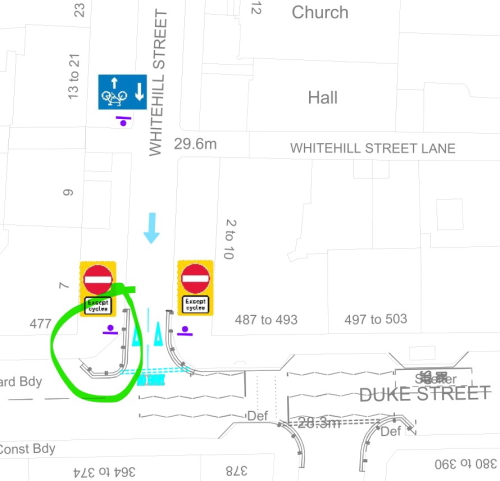
The Whitehill Street/Duke Street junction is a location frequently identified as suffering from parking offences and junction visibility issues. Is there scope for a temporary build-out (as shown on the issued drawings) to be tried out at the Whitehill Street/Duke Street junction as part of this “agile” and “readily adjusted scheme” (see attached image)?
DCC Q8: What arrangements are in place for compliance monitoring and enforcement measures?
GCC: Police Scotland are responsible for compliance and the enforcement of moving traffic violations. The Council’s enforcement team are responsible for the enforcement of any parking restrictions i.e double yellow lines.
DCC: Parking restrictions are, without question, not being effectively enforced in Dennistoun – why is that?
DCC Q9: How are various factors contributing to success or failure being measured and determined?
GCC: All immediately affected roads, plus surrounding roads will be monitored and any feedback from the local community and local ward members will also be considered.
DCC: As noted in our correspondence dated 15th March, this set of questions should be taken as a composite of community feedback following on from a series of public meetings discussing the scheme and items of correspondence received from people keen to provide feedback without (at that time) no clear way to do so directly to GCC. Some of the basic fundamental questions arising have not been answered. Where amendments to the scheme have been made, clear explanations have not been provided.
What is the method of monitoring of this scheme, and will any quantitative data be published?
DCC Q10: What and when are the next steps for traffic safety and management, and active travel provision, in Dennistoun in the event of success/failure (e.g. removing/reducing/keeping and maintaining/enhancing/extending this scheme; introducing similar measures elsewhere in Dennistoun; introducing the 20 mph limit previously proposed by the RPZ, etc)?
GCC: These measures have been installed using a Temporary Traffic Regulation Order. Such orders can only stay in force for a maximum of 18 months while the effects are monitored and reviewed. If the Council wish to make such measures permanent then they would need to follow a statutory process which includes consultation where members of the public can comment, object or support the proposals.
Moving forward, and in line with the Council’s liveable neighbourhoods strategy, measures to encourage active travel will be included as part of future parking control proposals. This will also include a 20mph zone and will form part of a full consultation process.
DCC: The Council website update on this scheme notes that elements of the original plan have been removed “whilst retaining and maintaining those which most broadly meet the aim of creating extra space for physical distancing”. This is a long way short of fulfilling the Council’s liveable neighbourhoods strategy, encouraging active travel, addressing parking issues, and incorporating a 20 mph zone.
If a permanent scheme to achieve all the stated Council aims is to be completed before the 18 month period for the current temporary scheme ends, it seems reasonable to suggest that a timeline or programme detailing various milestones will have already been identified such that a design can be developed for Dennistoun, including consultation and engagement with the community at a level beyond the basic statutory process for a permanent Traffic Regulation Order – is that the case?

One thought on “Update on Spaces for People ‘Low Traffic Neighbourhood’ scheme in Dennistoun”