Glasgow City Network Consultation

Cumbernauld Road Concept Visualisation
(click/tap image to view larger version)

Concept and Aims

Glasgow City Council has set out the concept of a City Network to provide a dense network of improved high-quality infrastructure across Glasgow, to be delivered by 2031. It is seeking your views on the latest proposals.

The network is aiming to link services and facilities across multiple neighbourhoods, providing easy and safe active journeys across Glasgow for everyone. This includes improved pedestrian infrastructure and protected cycle lanes.

It is part of a wider move toward providing infrastructure throughout Scotland, that is suitable for all road user types, and people of all abilities.

GCC is overseeing progress of the first two areas of the City Network – the Inner North and South – to concept designs by the end of the year. The route design proposals for both these areas are set out in the City Network storymap.

All of the infrastructure proposed has been designed in accordance with the guidance contained within Roads for All – Good Practice Guide for Roads and Cycling by Design, both produced by Transport Scotland to outline the requirements for inclusive design in road infrastructure, to comply with the Equality Act 2010 in Scotland. The guidance aims to ensure that road infrastructure is safe and accessible for everyone of all abilities, as part of Scotland’s broader efforts to promote active travel and achieve Vision Zero: halving road deaths by 2030, with zero fatalities and serious injuries on Scotland’s roads by 2050.

Glasgow City Network - Inner North Overview
Glasgow City Network – Inner North Overview
(click/tap image to view larger version)

Proposed Changes

Improving public spaces means making areas more inviting and enjoyable to spend time in and move through. This can be done by using better materials, adding greenery, incorporating art, and creating spaces for various activities.

The new designs for the City Network include changes that make spaces more attractive offering meeting and gathering places, while also promoting walking, wheeling, and cycling.

The proposed changes and additional themes may include:

  • Stopping Points: Rest areas with seating, planting (trees, shrubs and wildflower meadows) wayfinding signs, and water refill stations.
  • Improved Connections to Parks: Better links and access to existing parks.
  • Seating: Comfortable seating options to stop, rest and enjoy the surroundings.
  • Wayfinding: Accessible and clear signs to orient people navigating and exploring the area.
  • Water Taps: Accessible refill points for public use.
  • Bike Parking and Maintenance: Safe and secure places to park bikes. Stations for quick bike repairs and upkeep.
  • Tree and Shrub Planting: New planting for comfort, beauty, biodiversity and cleaner air.
  • Sustainable Urban Drainage (SUDs) Planting: Planting that helps manage water and supports wildlife.
  • Pedestrian Crossings: Safer and more accessible crossing points.
  • Upgraded Surfaces: Enhanced finishes on footways and paths in selected areas.

Dennistoun Area

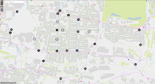
A route along parts of Alexandra Park Street. Alexandra Parade, and Cumbernauld Road is included within these Inner North proposals.

Alexandra Parade - Cumbernauld Road Drawing
Alexandra Parade – Cumbernauld Road Drawing
(click/tap image to view larger version)
Cumbernauld Road Drawing
(click/tap image to view larger version)

The broader ‘Dennistoun – Carntyne’ area is to be included in the next phase of the City Network (along with ‘Yoker – Whiteinch’ and ‘Greater Govan’).

City Network Phases
City Network Phasing

Consultation Details

This phase of consultation runs until Sunday 20th October. It’s the latest transport consultation in a series that have followed on from the ‘Public Conversation on Glasgow’s Transport Future’ held in Autumn 2020.

After viewing the designs, consider what features you would like to see along the routes of the City Network that would encourage and support you to walk, wheel or cycle more in these areas for everyday journeys. You are also invited to supply any other information that may impact any of the proposed Inner North or South City Network routes.

Printed copies available to view in libraries within the Inner North and South areas. This includes Dennistoun Library, 2A Craigpark, G31 2NA (0141 276 0768), open 10:00 to 17:00 Monday, Wednesday, Friday and Saturday; 10:00 to 20:00 Tuesday and Thursday.

Once the feedback has been collated from this consultation a Consultation Report will be prepared and will be published on the Council’s website and the project website. Then, at the next stage of the design process, from March 2025, there will be further opportunities to share your views.

Supporting Information

Further Information and Enquiries

Frequently Asked Questions:
https://storymaps.arcgis.com/stories/dbe98c5e1e334fd38ff9d8d7e35eebcc#ref-n-dI6llb

For any further queries, please contact gccin&sconsultation@aecom.com.

City Network
City Network
(click/tap image to view larger version)
Share

Engagement on Road Safety, Traffic and Parking in Dennistoun

Survey

Glasgow City Council (GCC) are seeking views on road safety, traffic, and parking in Dennistoun.

Dennistoun Community Council (DCC) encourages all residents, businesses and visitors to take part in the survey available via glasgow.gov.uk/dennistounparking, before the closing date of 13 October 2024.

GCC Information

GCC advises as follows:

“Parking and Road Safety has been an ongoing topic for discussion in the Denniston area for several years and has seen the Council implement various measures to address concerns. As part of the latest proposals to introduce parking controls in the area the Council have committed to carrying out a community engagement to establish the support and details for any parking controls and associated traffic measures in the area.”

“The purpose of carrying out the community engagement is to allow the Council to draft a scheme which is supported by the community prior to carrying out a statutory consultation associated with a Traffic Regulation Order or introduction of Traffic Calming measures.”

Timeline

GCC have provided the following proposed timeline to DCC:

  • 02 September 2024: All residential and commercial properties will receive a letter advising of the engagement by this date.
  • 13 October 2024: Closing date for survey comments.
  • November 2024: Draft scheme proposals.
  • December 2024: Traffic Regulation Order (TRO) Pre consultation.
  • January 2025: TRO Statutory Consultation commencing.

The Traffic Regulation Order procedure is the method required to introduce road safety and traffic controls such as one way streets, speed limits, yellow lines, and other parking measures.

Scope

The boundary of the area being considered by GCC is the only drawing provided so far.

Other than the above, DCC has not been provided with any further information about this engagement.

One Way Streets

Based on the questions asked in the GCC survey, it seems clear that a number of one way streets are being considered in addition to those already in place. DCC has created the basic sketch shown below to try and understand what the draft scheme proposals might include.

One Way Streets Sketch
One Way Streets Sketch (tap/click image for larger version)

DCC Priorities

The priorities of DCC have been consistent over many years: a safer and more accessible neighbourhood for everyone.

DCC recognises the multiple benefits of better streets for all: achieved by providing safe and accessible high-quality infrastructure.

DCC has been consistent in working towards that aim: by actively promoting and engaging with consultations carried out by GCC, and by seeking support from all our elected city councillors.

Considerations

It is hoped that the proposals due to be presented in November will include a variety of measures to provide better, safer streets.

Creating better streets requires more than just road signs and markings to introduce one way streets and parking restrictions.

Various measures are required, including the following:

  • New and better pedestrian crossing points. Some DCC proposals on this can be found here and here.
  • Better provision around schools and nurseries: a few planters placed on the carriageway cannot be expected to achieve this in any meaningful way.
  • Kerb splays require to be tightened up at corners to improve line-of-sight visibility for pedestrians and to reduce time spent on the carriageway when crossing roads at junctions.
  • Dropped kerbs along routes of pedestrian travel would make the area much more navigable for people in a wheelchair, or with a buggy/pushchair.
  • 20 mph speed limits on residential streets would contribute to improved safety, but inclusion in this scheme has not been confirmed.
  • Removing vehicular short-cut routes along residential streets, between main roads such as Duke Street and Alexandra Parade, would calm traffic. But the selection of one way streets being asked about in the survey would not achieve this.
  • If parking fees are being proposed, the structure of these requires to be properly explained or justified.

GCC has repeatedly stated that it has learned lessons from previous failures when it comes to engagement and consultation. It is therefore a matter of concern that multiple sources are reporting that the notification letter to “all residential and commercial properties” has not been received.

Background Information

Previous DCC engagement related to traffic in Dennistoun can be reviewed via dennistouncc.org.uk/tag/traffic.

Our meeting minutes available via dennistouncc.org.uk/minutes also provide a record of the ongoing activity in relation to this topic.

The dennistouncc.org.uk/about page contains a link to a statement on party-political neutrality, which can be read here.

Share

Neighbourhood Infrastructure Improvement Fund recommendations to Dennistoun Area Partnership

Glasgow City Council (GCC) have advised that, for the Dennistoun Community Council (DCC) proposals for pedestrian infrastructure improvements, in and around our area to be progressed as part of the £1 million per ward Neighbourhood Infrastructure Improvement Fund (NIIF), they require approval by the Dennistoun Area Partnership (DAP).

Since receiving that GCC response to DCC, the DAP meeting agenda for 19 September 2023 has been published. It can be viewed here. Item 3 provides an NIIF update report, accompanied by appendices listing various GCC proposals for £252,000 of road maintenance resurfacing work.

With the above noted, DCC provided the below information and recommendations to all councillors for the Dennistoun and Calton wards, and the GCC Neighbourhoods Liaison Manager.

A PDF of the below submission can be viewed here.

Continue reading Neighbourhood Infrastructure Improvement Fund recommendations to Dennistoun Area Partnership
Share

Proposals for Improvements to Pedestrian Infrastructure Provision

Dennistoun Pedestrian Proposals Plan

Dennistoun Community Council (DCC) recently compiled and submitted proposals to Glasgow City Council (GCC) identifying potential improvements to pedestrian infrastructure provision in and around our area.

A PDF of the full document can be viewed here. Images of each individual page of the document can be viewed below the summary that follows.

Updates: 12 September 2023: The GCC response to DCC can now be found at the bottom of this post. 18 September: DCC recommendations to the DAP can be found in a separate update post here.

Continue reading Proposals for Improvements to Pedestrian Infrastructure Provision
Share